This part of Peaklist is devoted to
the Tatras mountain range in Slovakia and Poland, Central Europe
by Mark Trengove
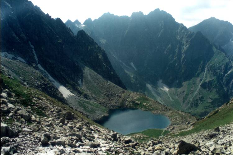
The High Tatra, with Ganek 2462m/182m in the left foreground (photo
courtesy Marcin Slupsky)
Introduction
The Tatras are the highest mountain range of the 1200 km (750 mile)
Carpathian Arch, which stretches from east of Vienna in Austria through
the Czech Republic, Slovakia, Poland, Hungary, and Ukraine, to Romania,
reaching an end at the Kazan Gorge on the Danube. Much of the
Carpathian chain is of lowly altitude. Almost half of its summits are
less than 1000m (3,280ft) in altitude. The Tatras, however, are
significantly higher. There are thirty-four summits with a prominence
of at least 140m (460ft) in the range that reach over 2000m (6,560ft)
in altitude. Of these six reach 2500m (8,200ft). Gerlachovsky stit, the
highest peak in the range, and its only Ultra-Prominence, is 2654.4m
(8709ft) in altitude.
These are rugged mountains with high cols and precipitous faces. The
absence of Prominences of 600 m and over indicates the wall-like nature
of the range. The Tatras’ main crest stretches in an arch from a
northwesterly to southeasterly direction. There are a number of spurs
from the main ridge, mostly perpendicular to it. The valleys, likewise,
follow a similar orientation to these spurs.
The main ridge stretches for some 78 km (49 miles) from the town of
Zuberec in Slovakia in the west to the valley of the Biela river in the
east – also in Slovakia. On average, the range is 20 km (12 miles)
wide. Beyond here to the northeast lie, at right angles to the main
ridge, the White Tatras. The Tatras are bounded on the northern side by
a series of valleys, in one of which the Polish town and mountain
resort of Zakopane lies. On the southern side lies the Sub-Tatras basin
in the wide valleys of the Poprad and Vah rivers. The total area of the
range is 785 sq. km, with 175 sq. km lying in Poland and the rest in
Slovakia.
Geology
The Tatras are built out of two types of rock. The oldest, in the
High Tatra, are crystalline granitoids formed from solidified magma in
the Palaeozoic Era (c.300 to 248 million years ago), although the
earliest were formed as far back as 415 million years ago. There
are also metamorphosed rocks such as gneisses from the same era, found
more in the Western Tatras. This forms the core of the main
ridge. The northern belt is composed of younger rocks formed in
the Mesozoic Era (230 to 65 million years ago). They are
sedimentary rocks such as limestone, dolomite and sandstone. They
were created at the bottom of a sea that lay far to the south in what
is now Slovakia. During the great period of mountain building in
the middle of the Tertiary Era (c. 50 to 40 million years ago) known as
the Alpine Orogeny, the collision of the African and Eurasian plates
created the Alps and, further east, the Tatras. This tectonic
movement also shifted the sedimentary rocks north over the crystalline
core and folded them to form the range of high hills in Poland which
lie north of the range.
Erosion
Most of the Carpathian chain escaped glaciation in the Quaternary (Ice)
Age. Due to their northerly position in the chain and higher
altitude, however, the Tatras did not. Glaciation covered all
higher areas of the High Tatras and parts of the Western Tatras.
Valleys were gouged by the glaciers into the characteristic
U-shape. Hanging valleys were created in subsidiary
valleys. The glacial erosion sharpened the mountain ridges and
formed deep cirques, with terminal moraines creating large numbers of
glacial lakes after the ice had retreated. Material carried down
by the glaciers to the foreland formed glacial cones, on one of which
the Polish town of Zakopane now stands. The glaciers disappeared
from the Tatras about 10,000 years ago. There is now no permanent
lying snow on the mountains.
Today the Tatras continue to be shaped by the forces of water, wind and
weather, and vegetation. Man has also contributed to this
erosion. The weather in the Tatras is often changeable and can be
harsh. Snow can fall at almost any time of year. The
average annual precipitation is between 1200mm and 1500mm, with half of
it falling as snow. Powerful warm southerly winds called “halny”
(foehn) can blow over the mountains on the Polish side. These
are strong enough to break down trees and destroy swathes of forest.
The White Tatras (Slovak:
‘Bielanske Tatry’)
Havran 2052m/401m (left) and Zdiarska vidla 2142m/c.172m (photo
courtesy Marcin Slupsky
This subsidiary range in the east, wholly in Slovakia, lies at right
angles to the main Tatras ridge, connected to it by the by the col
Kopské sedlo. It is 13km (8 miles) long and composed
of pale grey limestone summits which rise out of steep grass-covered
slopes. The highest summit in the range is Havran 2052m/401m
(7059ft/1317ft). There are a further five summits in the
range with a prominence of over 140m/460ft.
Due to extensive erosion and the threat to their delicate ecology, the
National Park Authority limits the number of visitors to this range and
the number of routes onto and along the ridge.
The High Tatras (Slovak:
‘Vysoké Tatry’ ; Polish: ‘Tatry Wysokie’)
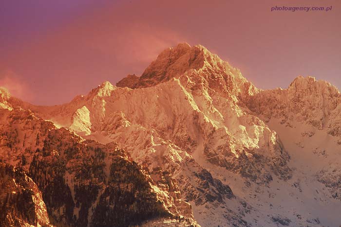
Gerlachovsky Stit 2654m/2356m in winter (photo courtesy Dariusz Zarod)
The High Tatras form the highest part of the chain. They begin in
the east in Slovakia at the col Kopské sedlo, with the main
ridge stretching for most of the way in a southwesterly direction
before swinging northwestwards to reach the Polish border at the
mountain Rysy. From there the main ridge continues to head north
west, forming the Slovak/Polish border as far as the col
Laliové sedlo if you follow Slovak opinion. There are a
number of spurs off the main
ridge northwards into Poland and southwards into Slovakia – most
notably the subsidiary chain southwestwards for 7km (4 miles) from
Cubryna, reaching its highest point on
the
summit of Kriván 2494m/400m (8182ft/1312ft). The main
ridge stretches for a distance of 27km (17 miles).
The highest summit is Gerlachovský štít
2654m/2356m (8709ft/7731 ft) in Slovakia which lies on a southern spur
off the main ridge. The highest summit of significant prominence in
Poland is Mieguszowiecki Szczyt 2438m/213m (7999ft/699ft) which lies on
the Polish/Slovak border. Many books note Rysy as the highest
summit in Poland. The Polish high point, however, is on a subsidiary
summit of the mountain at 2499m (8199ft) with only 10m of prominence.
The main summit lies just across the border at 2503m (8212ft), giving
the mountain a prominence value of 163m (536ft). The highest mountain
wholly in Poland is Kozi Wierch 2291m/165m (7517ft/542ft).
The High Tatras are composed mainly of hard granites and
gneisses. They are spectacularly serrated and precipitous peaks,
some only being accessible to rock climbers and generally requiring a
guide. There are, however, a number of summits accessible to
walkers. These require little use of the hands but do need a head
for heights.
The Western Tatras (Slovak:
‘Západné Tatry’ ; Polish: ‘Tatry Zachodnie’)
The Western Tatras are a continuation of the High Tatra ridge, forming
the border between Slovakia and Poland as far as Volovec/Wolowiec
2064m/156m (6772ft/512ft). Thereafter the crest of the main ridge
is wholly in
Slovakia. The Western Tatras main ridge begins in the east at
Laliové sedlo and stretches for some
38 km (24 miles) westwards. A series of subsidiary spurs stretch
off the main ridge into Slovakia and Poland. The Western Tatras
are the second highest range of mountains in Slovakia and Poland.
The highest summit in the range is Bystrá 2248m/562m
(7377ft/1845ft) which lies off the main ridge on a spur in
Slovakia. The highest summit in Poland is Starorobocianski Wierch
2176m/238m (7138ft/780ft), which lies on the Polish/Slovak
border. There are twenty summits with at least 140m (460ft) of
prominence in this range.
The Western Tatras are mainly composed of gneisses and slate-type
(metamorphic) rocks and have a smoother and less jagged appearance than
the High Tatras. They provide good ridge walking, however, and
are more accessible to un-guided visitors.
Hiking in the Tatras
The Tatras first became popular for visitors in the 19th Century with
the aristocracy of the Austro-Hungarian Empire. During the years of
communist domination the Tatras were the most accessible region of
alpine mountains to those in Central and Eastern Europe behind the
‘Iron Curtain’. Their popularity has continued to this day. These are
not mountains which you can expect to have to yourself if you keep to
the marked trails. The weight of visitors has land caused degradation
problems. It is for this reason that access to the areas of the Slovak
and Polish National Parks is quite tightly regulated.
The Slovak and Polish Tatra National Parks are blessed with a network
of well-maintained and waymarked paths. The National Park regulations
on both sides of the border require hikers to keep to these paths
unless accompanied by a qualified guide or they are in possession of a
valid identity card from their national Alpine club. In Poland groups
of ten or more must be accompanied by a guide, even on waymarked paths.
There is also a small entry fee for entering National Park areas in
Poland. These fees go to maintaining the Parks and funding the free
mountain rescue service. The higher routes are closed to hikers in
winter and spring (generally 1 November to 30 June), but the lower
paths remain open in Slovakia. As mentioned above, the White Tatras are
only accessible at any time of year when in possession of a valid pass,
except for a marked trail between Zdiar and Kopske sedlo.
There are a good number of mountain refuges in these mountains. In
Slovakia there are eleven of these “chaty”, and Poland has eight
“schronisko”. Most of these refuges are owned by the relevant national
mountaineering associations. All offer food and lodging, with some
reaching good hotel standards. Details on how to contact these refuges
can be found in the guidebooks mentioned below.
Maps
There is a good choice of maps of the Tatras at 1:25,000, 1:50,000 and
1:75,000 scales. It must be said, however, that even the smaller
scale maps tend to lack contouring in the more precipitous higher
mountain areas. This is particularly the case with the Slovak
maps.
For Slovakia, the following 1:25,000 maps are recommended:
For Poland, the following 1:25,000 map is recommended:
• Sygnatura Tatra National Park Tourist
Map/Wanderkarte (in English and German) (2004/05).
Guide books
There are a wide selection of guidebooks on the Tatras in Polish and
Slovak. For English speakers, the following are recommended:
• The High Tatras by Colin Saunders and
Renáta Náro_ná. Publisher Cicerone Press,
England (website).
• High Tatra: the finest valley and mountain
walks by Stanislav Samuhel. Publisher Rother, Munich (website).
I would also recommend the following websites for pictures of the
Tatras: