CALIFORNIA HOME
PAGE
GUIDE TO
THE SUMMITS OF CALIFORNIA
 Welcome to California. In this section:
P5000
- the 9 Ultra Prominences
P2000 - 169 Summits Across California
P500 - the California
Mountain Atlas
Project, 3,800 summits
GEOGRAPHY
OF CALIFORNIA
The purpose of this section is to give the reader a broad view
of how prominence works over a well-defined geography.
Different prominence cutoffs allow us to view terrain at
different
levels of granularity. This page looks at California at three
very different scales.
Firstly, California can be expressed as a set of nine "ultra-prominences" - the
summits with 5,000' and greater prominence. Each mountain is the
representative of a large area of mountainous terrain -- groups of
summits that comprise a
discreet topographic region.
Secondly, California can be expressed as a set of 169
summits.
This is the set of all summits with
2,000' and greater prominence. They are widely distributed
across every physiographic region of the state.
Lastly, we can examine the full dataset of summits for the
state.
The California Mountain Atlas
chronicles over 3,800 peaks in the state - organized in a logical
hierarchy of lineage groups and cells.
Submission of articles to this page are welcomed. If
you
are
interested in the geographical and statistical distribution of summits,
click on the following link:
PROMINENCE
DISTRIBUTION OF
CALIFORNIA
==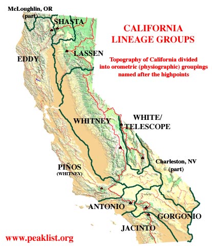
P 5000s: THE 9 ULTRA-PROMINENCES
California has nine of the big boys: Summits that stand
5,000 feet
above all else. Three are in the north of the state -- Mt.
Eddy, Mt. Shasta and Mt. Lassen. Three are in the Southern
California Transverse Ranges -- Mt. San Antonio, San Gorgonio Mtn., and
San Jacinto Peak. The Sierra Nevada claims just
one, its highpoint Mt. Whitney. The remaining two are in the high
basin and range -- White Mountain Peak and Telescope Peak. It's a
nice set to climb:
Mt. Shasta is the most difficult, the rest are entirely non-technical.
Mt. Eddy
Mt. Lassen
Mt. San Antonio (Mt. Baldy)
San Gorgonio Mtn.
San Jacinto Peak
Mt. Shasta
Telescope Peak
White Mtn. Peak
Mt. Whitney
The Ultras form the basis for the organization of California's
topography. Lineage Cells are formed by tracing channel
lines (channels, pits, and basin saddles) from their key saddles to the
oceans. (If the terminology is confusing, take the short course on prominence theory
and orometry.) Basically this is analogous to tracing the
watercourses from the low points between summits.
I have added Mt. Piños to the map on the right (P4800) and in
the
California Mountain Atlas, because it forms a natural group of the
Coastal Ranges that constitute a physiographic region distinct from the
rest of the Whitney group.
P
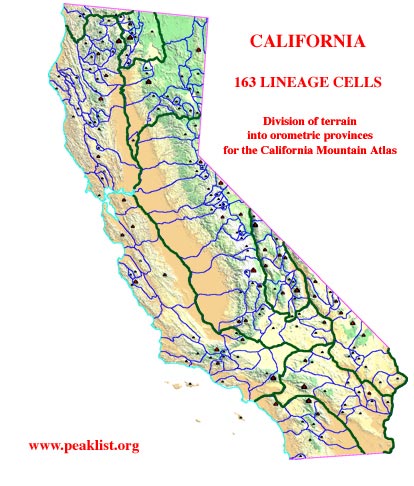
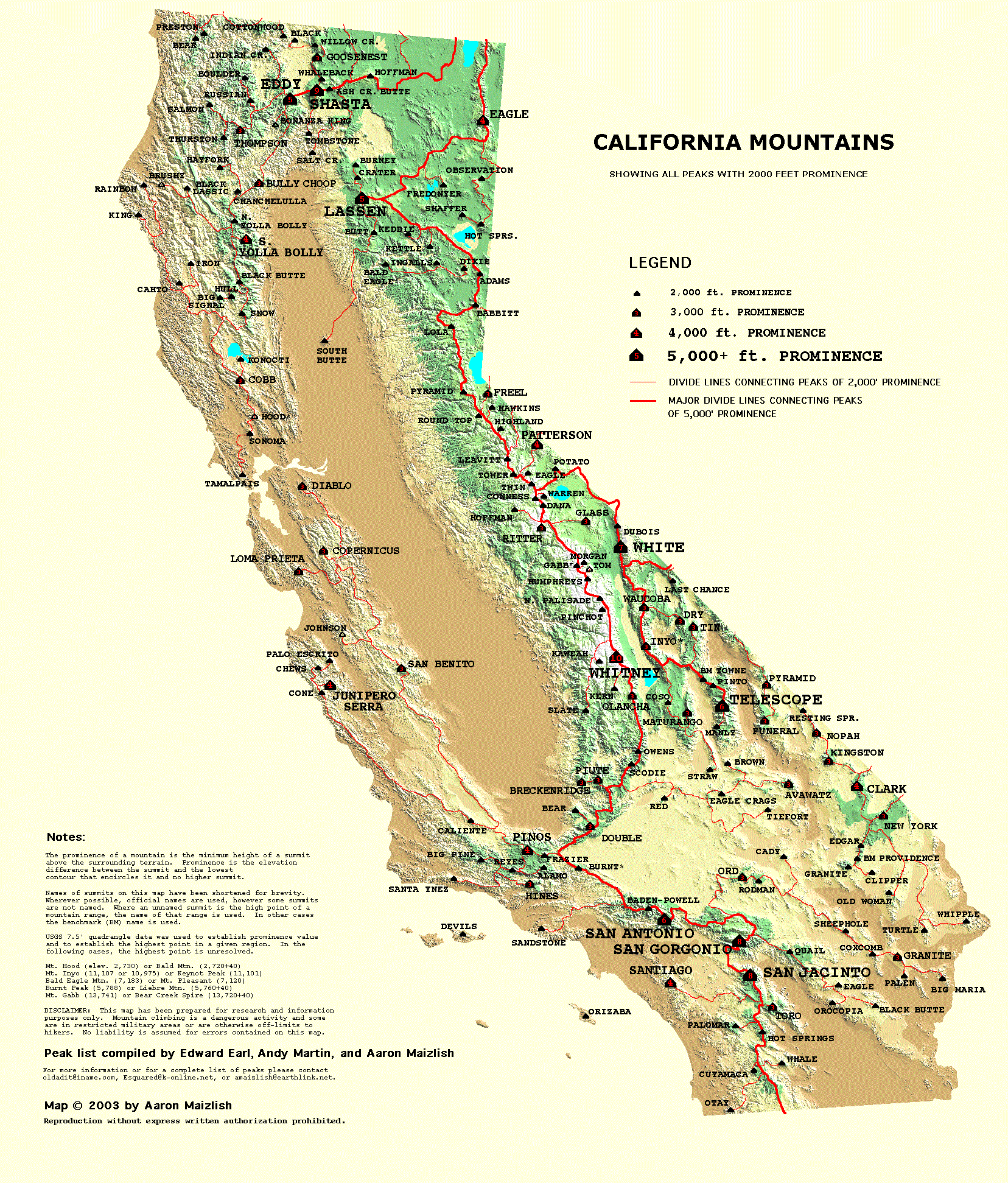
2000s: THE 169 SUMMITS IN CALIFORNIA
163 Peaks satsify the criterion for 2,000' of clean prominence (there
are six additional in the "error range.")
Names, elevations and prominence values on the peaklist are
derived from printed USGS maps.
All prominence values are based on USGS printed elevations, as with the
rest of the United States. Note that elevation values on the USGS
topographic maps are based on an earlier
vertical datum, NAVD29 which is no longer in use. New sources of
digital
elevation data rely on NGVD88; based on a different
methodology for measuring the geoid. The geoid is
the theoretical shape of the earth where the specific gravity is held
constant. NGVD88 is the basis for GPS elevations. The
transition from NAVD29 to NGVD88 will result in
higher elevations of most of America's mountains. In California
this seems to mostly vary from 1-15 feet. For example, Mt.
Whitney,
previously 14,495' (although the topographic map says 14,491' in
error), now measures 14,505' under the new datum.
Richard Carey and Aaron Maizlish have both researched new elevation
values for most of California's P2000 summits (those with NGS or USGS
vertical control benchmarks.) In addition, surprisingly,
investigation
by Aaron Maizlish demonstrates that as many as 25% of the benchmarks
are recorded as being originally placed anywhere from 1' to 20' below
the true natural summit
of a peak. Thus, even under the old NAVD29 system, printed
elevations were often under-reported on USGS maps. The maps
indicated the elevation of the benchmark, not necssarily the highest
natural point on the summit. The combination of these two error
bounds will result
in some surprising new elevation values, which should be considered
more authoritive than widely publicized USGS map derived values.
** NEW ELEVATIONS** for California
Summits -- this page is not on-line yet, in the
meantime, you can see the NGVD88 values on Richard Carey's peakbagging.com website.
P 500s: THE CALIFORNIA MOUNTAIN
ATLAS
 The California
Mountain Atlas is a complete listing of
3,800
summits
of ≥P500 that span the entire state. The lists and maps
give perhaps the clearest picture yet of the topographic properties of
summits and divides over a wide and varied terrain.
The California
Mountain Atlas is a complete listing of
3,800
summits
of ≥P500 that span the entire state. The lists and maps
give perhaps the clearest picture yet of the topographic properties of
summits and divides over a wide and varied terrain.
Research for the atlas was largely completed in Winter 2003-04.
Efforts to put the results online are ongoing. In the meantime if
you don't find what you want on the web pages, feel free to contact the
author (sorry the Sierra are
going to take some time to finish.)
The atlas is organized around the principle of lineage
groups and cells. This is a simple, non-arbitrary system for
describing mountainous terrain, but it takes a little getting used
to. Before you spend a lot of time
with the data in this atlas, it may be
helpful to take the short course on "Orometry" . It explains the
principles and terminology governing such concepts as lineage cells and
groups, divides, key
saddles, basin saddles, and other topological functions of the
terrain.
How
to Use the California Mountain
Atlas; a quick reference
Short Course on Prominence and Orometry
The first level of organization in the Atlas is the division of
California into eight physiographic regions, roughly based on the
Ultras.
The second level of organization is the division of the
state into 163 orometric provinces - "Lineage Cells" - based on the
P2000s. Each summit with more than 2,000 feet of prominence is
assigned a conterminous area of terrain of which it is the highest
point. All summits within the bounds count the P2000 in their
lineage. The schematic map on the right illustrates how terrain
is divided using lineage cell principles.
Most of us are accustomed to grouping sets of mountains by their named
mountain ranges. While this is handy for orientation, it is an
insufficient means for categorizing the world's summits. A
mountain range, like a mountain itself, is an object without a
well-defined perimeter. In fact, a mountain range is part
physiographical (a region of continuous uplift) part geomorphological
(a region of common geologic formation and origin) and part
socio-cultural (a region defined by its use value). Some
smaller ranges are named, some are not. Some mountain ranges are
discontinuous or bisected by rivers without gaining separate
names. Foothills are sometimes included with a mountain range,
sometimes separated. Lineage theory on the other hand is solely
derived from elevation, and thus lends itself to well-defined
borders.
It so happens that the California lineage groups lend themselves to
well-defined physiographic regions. For example, the Eddy Group
includes all Coast Ranges south of the Klamath River and west of
Interstate 5 south to San Francisco. The Pinos Group neatly
includes all Coast Ranges south of San Francisco to Soledad Pass (north
of Los Angeles) and the Tehachapi Mountains. The Southern
California Transverse Ranges are neatly divided into three groups
separated by two low passes, Cajon Pass (I-15) and San Gorgonio Pass
(I-10). The Lassen Group is separated from the Whitney Group at
Beckwourth Pass near the Sierra Valley.
Thus California's natural mountain ranges neatly fit into
lineage-derived groups. On the other hand, the Mojave Desert is
apportioned into five separate groups. As it is not a region of
continuous uplift, the desert ranges are divided by the imaginary
drainages that would flow if the region were well-watered.
As the California Mountain Atlas goes on-line I will be posting
some special sections on this page, including some lists for the Sierra.