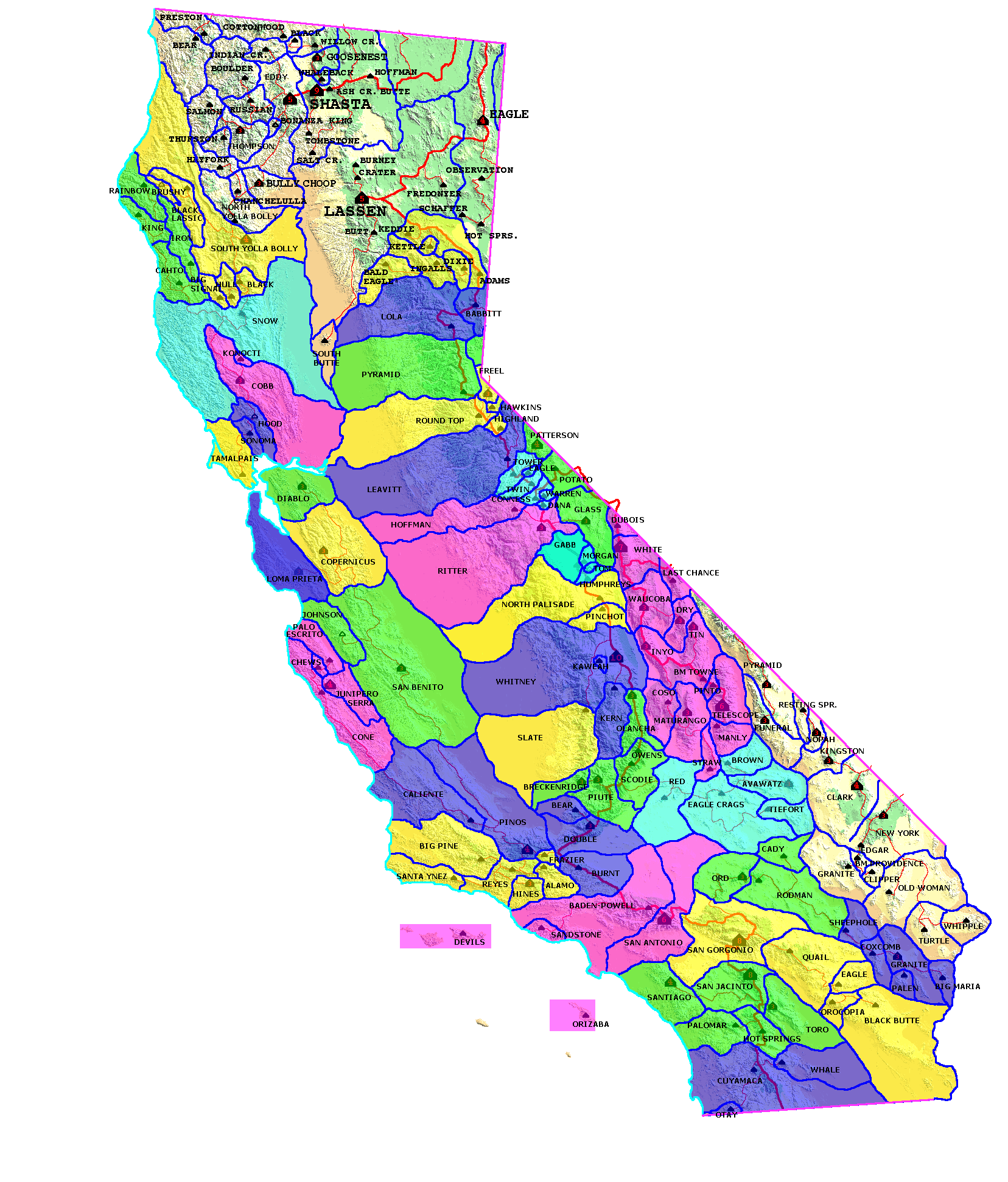
| California Cell Reference Map |
California
Mountain
Atlas Home Page |
Peaklist Home Page |
Notes
and Key to California Mountain Atlas |
| Rank |
Summit | Elev | E (e) | Prom | Saddle | S (e) | Lat. | Long. |
| 1 |
HP Avawatz Mtns. | 6154 | |
3294 | 2860 | 20 | 35˚ 30' 45" N | 116˚ 19' 52" W |
| 2 |
HP Granite Mtns. | 5295 | |
1855 | 3440 | 40 | 35˚ 27' 05" N | 116˚ 35' 47" W |
| 3 |
HP Cave Mtns. | 3624 | |
1744 | 1880 | 40 | 35˚ 04' 15" N | 116˚ 19' 25" W |
| 4 |
BM Stone | 4880 | |
1600 | 3280 | 40 | 35˚ 21' 41" N | 116˚ 48' 05" W |
| 5 |
Calico Peak | 4542 | |
1502 | 3040 | 40 | 34˚ 59' 44" N | 116˚ 50' 19" W |
| 6 |
BM Leach | 4862 | |
1222 | 3640 | 40 | 35˚ 32' 05" N | 116˚ 53' 27" W |
| 7 |
Lane Mtn. | 4522 | |
1162 | 3360 | 40 | 35˚ 05' 26" N | 116˚ 56' 22" W |
| 8 |
BM Oslund | 4534 | |
1137 | 3397 | 37 | 35˚ 14' 26" N | 116˚ 52' 05" W |
| 9 |
Pt. 4977 | 4977 | |
937 | 4040 | 40 | 35˚ 27' 53" N | 116˚ 32' 09" W |
| 10 |
Alvord Peak | 3456 | |
896 | 2560 | 40 | 35˚ 05' 51" N | 116˚ 37' 10" W |
| 11 |
Pt. 3695 | 3695 | |
895 | 2800 | 20 | 34˚ 56' 23" N | 116˚ 48' 34" W |
| 12 |
BM James | 4810 | 0 | 873 | 3937 | 33 | 35˚ 31' 53" N | 116˚ 32' 59" W |
| 13 |
Pt. 1761m | 5777 | 0 | 856 | 4921 | 33 | 35˚ 31' 35" N | 116˚ 18' 03" W |
| 14 |
BM Mesa | 4137 | |
817 | 3320 | 20 | 35˚ 10' 31" N | 117˚ 04' 15" W |
| 15 |
HP Cronise Mtns. | 2360 | 40 | 811 | 1549 | |
35˚ 06' 47" N | 116˚ 18' 40" W |
| 16 |
BM Grave | 4231 | |
791 | 3440 | 40 | 35˚ 25' 07" N | 116˚ 29' 06" W |
| 17 |
BM Alvin | 3270 | |
790 | 2480 | 40 | 35˚ 22' 32" N | 116˚ 17' 56" W |
| 18 |
Pt. 2657 | 2657 | |
777 | 1880 | 10 | 35˚ 06' 28" N | 116˚ 24' 29" W |
| 19 |
Pt. 3951 | 3951 | |
771 | 3180 | 20 | 35˚ 10' 22" N | 117˚ 10' 31" W |
| 20 |
Pt. 1505m | 4938 | 0 | 771 | 4167 | 33 | 35˚ 31' 43" N | 116˚ 27' 07" W |
| 21 |
BM Erwin | 3640 | 40 | 760 | 2880 | 40 | 35˚ 17' 09" N | 116˚ 42' 27" W |
| 22 |
Pt. 4097 | 4097 | |
737 | 3360 | 20 | 35˚ 08' 00" N | 117˚ 04' 00" W |
| 23 |
Pt. 1437m | 4715 | 0 | 679 | 4035 | 33 | 35˚ 31' 45" N | 116˚ 48' 28" W |
| 24 |
BM Board | 4108 | |
668 | 3440 | 40 | 35˚ 23' 52" N | 116˚ 51' 49" W |
| 25 |
Mt. General | 2926 | |
646 | 2280 | 10 | 34˚ 57' 14" N | 117˚ 07' 47" W |
| 26 |
Pt. 4842 | 4842 | |
642 | 4200 | 40 | 35˚ 27' 45" N | 116˚ 38' 14" W |
| 27 |
BM Nelson | 3919 | |
639 | 3280 | 40 | 35˚ 23' 46" N | 116˚ 42' 38" W |
| 28 |
Pt. 2557 | 2557 | |
631 | 1926 | |
35˚ 06' 21" N | 116˚ 26' 18" W |
| 29 |
Pt. 3692 | 3692 | |
612 | 3080 | 40 | 35˚ 24' 10" N | 116˚ 23' 16" W |
| 30 |
Pt. 4245 | 4245 | |
605 | 3640 | 40 | 35˚ 28' 20" N | 116˚ 26' 06" W |
| 31 |
BM Dunn | 2784 | |
584 | 2200 | 40 | 35˚ 03' 15" N | 116˚ 28' 09" W |
| 32 |
Pt. 3783 | 3783 | |
583 | 3200 | 20 | 34˚ 59' 01" N | 116˚ 48' 47" W |
| 33 |
Pt. 1619m | 5312 | 0 | 554 | 4757 | 33 | 35˚ 30' 53" N | 116˚ 25' 01" W |
| 34 |
BM Wells | 3879 | |
552 | 3327 | |
35˚ 09' 45" N | 117˚ 00' 42" W |
| 35 |
Pt. 1357m | 4452 | 0 | 548 | 3904 | 33 | 35˚ 30' 19" N | 116˚ 43' 30" W |
| 36 |
Pt. 3647 | 3647 | |
543 | 3104 | 24 | 35˚ 15' 58" N | 116˚ 58' 06" W |
| 37 |
Pt. 2280+ | 2280 | 40 | 540 | 1740 | 40 | 35˚ 06' 00" N | 116˚ 19' 35" W |
| 38 |
Pt. 4040+ | 4040 | 40 | 539 | 3501 | |
35˚ 18' 40" N | 116˚ 50' 58" W |
| 39 |
Pt. 4493 | 4493 | |
533 | 3960 | 40 | 35˚ 24' 55" N | 116˚ 32' 19" W |
| 40 |
Opal Mtn. | 3951 | |
531 | 3420 | 20 | 35˚ 09' 35" N | 117˚ 11' 13" W |
| 41 |
HP Salt Spring Hills | 1939 | 0 | 528 | 1411 | 33 | 35˚ 35' 57" N | 116˚ 16' 35" W |
| 42 |
Pt. 4567 | 4567 | |
527 | 4040 | 40 | 35˚ 28' 20" N | 116˚ 16' 24" W |
| 43 |
Pt. 4801 | 4801 | |
521 | 4280 | 40 | 35˚ 28' 17" N | 116˚ 41' 05" W |
| 44 |
Pt. 3760+ | 3760 | 40 | 520 | 3240 | 40 | 35˚ 02' 46" N | 116˚ 55' 15" W |
| 45 |
Pt. 3760+ | 3760 | 40 | 520 | 3240 | 40 | 35˚ 02' 07" N | 116˚ 54' 41" W |
| 46 |
Pt. 2675 | 2675 | |
515 | 2160 | 40 | 35˚ 05' 24" N | 116˚ 28' 00" W |
| 47 |
Pt. 2148 | 2148 | |
508 | 1640 | 40 | 35˚ 11' 57" N | 116˚ 26' 23" W |
| 48 |
Pt. 1730m+ | 5676 | 33 | 492 | 5184 | 33 | 35˚ 31' 34" N | 116˚ 22' 02" W |
| 49 |
BM Granite | 4462 | 0 | 492 | 3970 | 33 | 35˚ 31' 12" N | 116˚ 44' 55" W |
| 50 |
BM Bill | 4468 | |
488 | 3980 | 40 | 35˚ 15' 26" N | 116˚ 48' 05" W |