DEVILS
PEAK
Channel
Islands, Santa Barbara County
List of
all P500 summits on the cell:
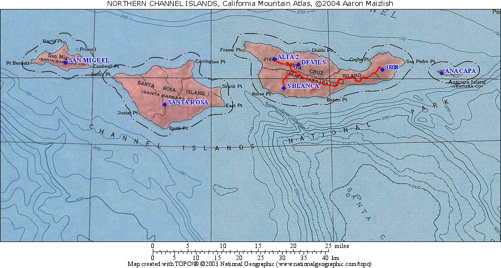
The Devils cell has seven summits including four on Santa Cruz Island,
and the highpoints of Santa Rosa, San Miguel and Anacapa Islands.
edited: February 26, 2005
| Rank |
Summit |
Elevation |
E(e) |
Prominence |
Saddle |
S(e) |
Lat. |
Long. |
|
|
|
|
|
|
|
|
|
|
|
| 1 |
Devils Peak |
2470 |
|
2470 |
0 |
|
34º01'45"N |
119º47'04"W |
[1]
|
| 2 |
HP Santa Rosa Island |
1589 |
|
1589 |
0 |
|
33º56'43"N |
120º07'03"W |
|
| 3 |
"El Montañon"
|
1808 |
42
|
1308 |
500 |
50 |
34º01'05"N |
119º34'29"W |
[3]
|
| 4 |
HP Anacapa Island |
930 |
|
930 |
0 |
|
34º00'39"N |
119º25'40"W |
|
| 5 |
HP San Miguel Island |
831 |
|
831 |
0 |
|
34º01'59"N |
120º21'52"W |
|
| 6 |
BM Alta 2 |
2167 |
|
667 |
1500 |
50 |
34º02'25"N |
119º50'38"W |
|
| 7 |
Sierra Blanca |
1523 |
|
573 |
950 |
50 |
33º58'49"N |
119º49'15"W |
|
[1] Devils Peak: This peak is on Nature Conservancy
property. It is reachable by advance permit. The benchmark
(EW8071) indicates an elevation of 2470. With the new datum the
elevation should be 2474. The earlier published elevation of
2475' is probably an interpolation of the 50' contour interval.
[3] El Montañon: This is the highest point of
the eastern part of Santa Cruz Island, which belongs to the National
Park Service. The name appears on NPS maps but not the USGS 7.5"
map. A May 2004 visit by Richard Carey, Edward Earl, Andy Martin
and Gerry Roach et. al. indicates that the 1800-1850' contour 500' to
the NW of BM 1808 is the true high point. They estimate the
actual high point at 1813'.