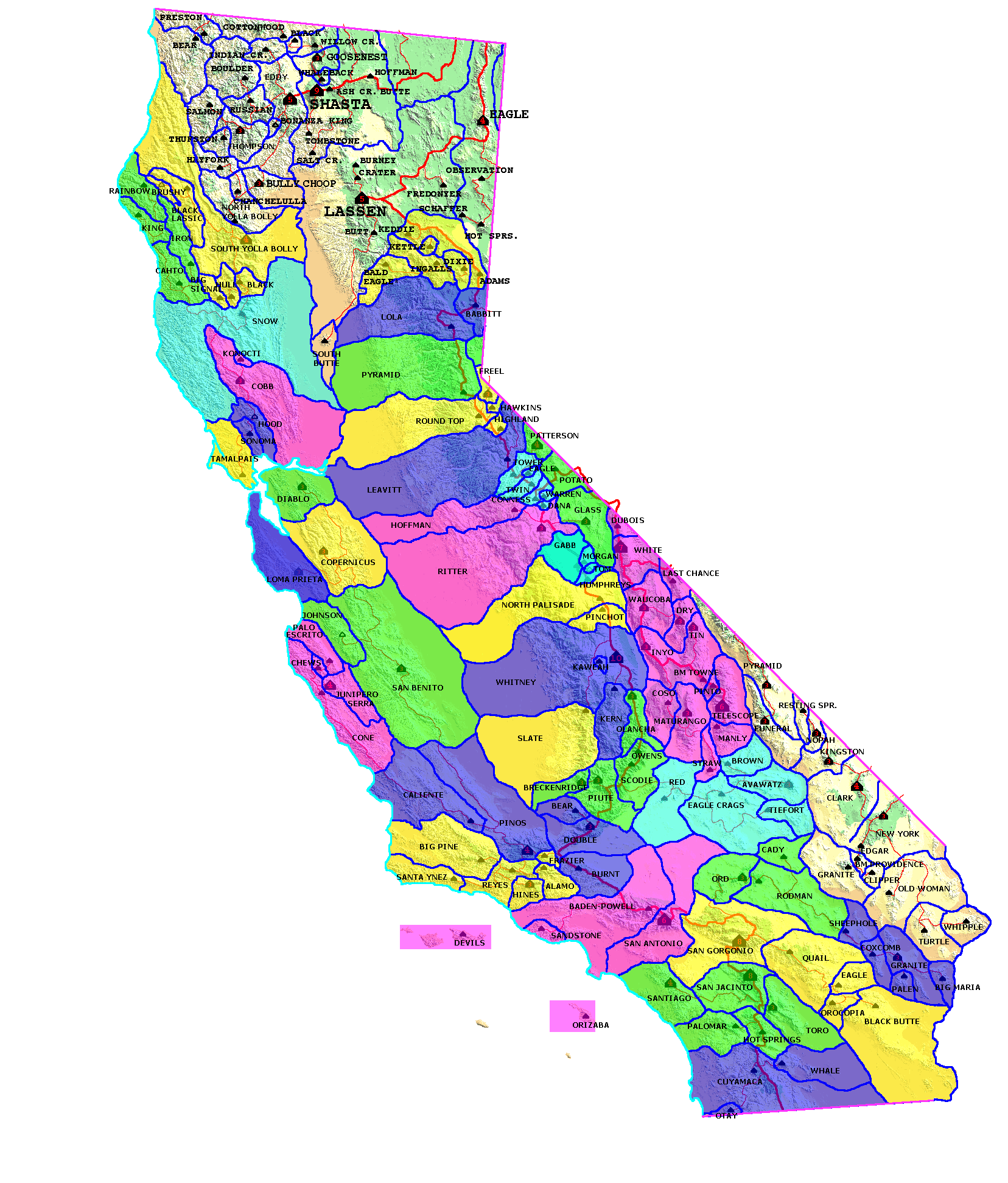
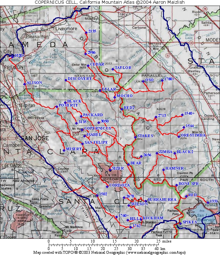
| California Cell Reference Map |
California
Mountain
Atlas Home Page |
Peaklist Home Page |
Notes
and Key to California Mountain Atlas |
| Rank |
Summit | Elevation | E(e) | Prominence | Saddle | S(e) | Latitude | Longitude | |
| 1 | Copernicus Peak | 4372 | 3092 | 1280 | 40 | 37º 20' 49" N | 121º 37' 48" W | ||
| 2 | Eylar Mtn. | 4089 | 1929 | 2160 | 40 | 37º 28' 39" N | 121º 33' 21" W | ||
| 3 |
Mt. Alison | 2658 | 1578 | 1080 | 40 | 37º 29' 56" N | 121º 52' 16" W | ||
| 4 |
Black Mtn. | 3951 | 1551 | 2400 | 40 | 37º 26' 14" N | 121º 42' 03" W | ||
| 5 |
Mt. Stakes | 3804 | 1404 | 2400 | 40 | 37º 19' 20" N | 121º 24' 30" W | ||
| 6 |
"Discovery Peak"- (HP Alameda Co.) |
3841 | 1081 | 2760 | 40 | 37º 30' 44" N | 121º 41' 57" W | ||
| 7 | Robinson Mtn. (Pt. 2656) | 2656 | 1056 | 1600 | 40 | 37º 15' 29" N | 121º 22' 58" W | [7] |
|
| 8 | HP Poverty Ridge | 3301 | 1021 | 2280 | 40 | 37º 25' 25" N | 121º 44' 14" W | ||
| 9 | BM Zimba | 2585 | 975 | 1610 | 37º 16' 07" N | 121º 19' 05" W | |||
| 10 | Black Mtn. | 2269 | 949 | 1320 | 40 | 37º 16' 06" N | 121º 14' 36" W | ||
| 11 | Mt. Oso | 3347 | 947 | 2400 | 40 | 37º 30' 30" N | 121º 22' 30" W | ||
| 12 | Pt. 3050 | 3050 | 930 | 2120 | 40 | 37º 22' 17" N | 121º 33' 38" W | ||
| 13 | Bone Spring Hill | 2509 | 869 | 1640 | 40 | 37º 09' 44" N | 121º 14' 08" W | ||
| 14 | Mt. Misery | 2502 | 862 | 1640 | 40 | 37º 16' 40" N | 121º 42' 21" W | ||
| 15 | Red Hill | 2402 | 842 | 1560 | 40 | 37º 07' 30" N | 121º 11' 40" W | ||
| 16 | Pt. 2713 | 2713 | 809 | 1904 | 37º 23' 22" N | 121º 19' 20" W | |||
| 17 | Mt. Isabel | 4230 | 790 | 3440 | 40 | 37º 19' 34" N | 121º 37' 14" W | ||
| 18 | Red Mtn. | 3675 | 755 | 2920 | 40 | 37º 24' 58" N | 121º 27' 51" W | ||
| 19 | 0.5 mi. N. of Mt. Mocho | 3672 | 752 | 2920 | 40 |
37º 27' 20" N | 121º 29' 40" W | ||
| 20 | Pt. 2986 | 2986 | 706 | 2280 | 40 | 37º 36' 02" N | 121º 36' 59" W | ||
| 21 | Pt. 1760+ | 1760 | 40 | 680 | 1080 | 40 | 37º 03' 23" N | 121º 29' 12" W | |
| 22 | Cedar Mtn. | 3675 | 675 | 3000 | 40 | 37º 33' 36" N | 121º 36' 22" W | ||
| 23 | Pt. 3135 | 3135 | 655 | 2480 | 40 | 37º 22' 07" N | 121º 39' 17" W | ||
| 24 | Pt. 1331 | 1331 | 651 | 680 | 40 | 37º 06' 16" N | 121º 06' 14" W | ||
| 26 | Pt. 1320+ | 1320 | 40 | 640 | 680 | 40 | 37º 35' 21" N | 121º 55' 23" W | |
| 25 | Kickham Peak | 2320 | 40 | 640 | 1680 | 40 | 37º 02' 52" N | 121º 23' 05" W | |
| 27 | Orestimba Peak | 2074 | 634 | 1440 | 40 | 37º 19' 25" N | 121º 13' 33" W | ||
| 28 | Hamner Hill | 2429 | 629 | 1800 | 40 | 37º 12' 49" N | 121º 17' 27" W | ||
| 29 | Bills Hill | 1988 | 628 | 1360 | 40 | 37º 02' 44" N | 121º 26' 22" W | ||
| 30 | Pt. 1544 | 1544 | 624 | 920 | 40 | 37º 21' 19" N | 121º 12' 17" W | ||
| 31 | Pt. 1780+ | 1780 | 20 | 620 | 1160 | 20 | 37º 30' 41" N | 121º 17' 45" W | |
| 32 | Pt. 1762 | 1762 | 602 | 1160 | 40 | 37º 01' 19" N | 121º 25' 38" W | ||
| 33 | Mt. Sizer | 3215 | 575 | 2640 | 40 | 37º 12' 50" N | 121º 30' 49" W | ||
| 34 | HP Cordoza Ridge | 2854 | 26 | 574 | 2280 | 40 | 37º 09' 28" N | 121º 31' 31" W | |
| 35 | Wilson Peak | 2651 | 571 | 2080 | 40 | 37º 05' 43" N | 121º 26' 07" W | ||
| 36 | Pt. 1502 | 1502 | 562 | 940 | 20 | 37º 07' 43" N | 121º 34' 03" W | ||
| 37 | HP San Felipe Hills | 3320 | 40 | 560 | 2760 | 40 | 37º 18' 00" N | 121º 37' 47" W | |
| 38 | Pt. 2153 | 2153 | 553 | 1600 | 37º 40' 17" N | 121º 36' 50" W | |||
| 39 | Packard Ridge | 3460 | 540 | 2920 | 40 | 37º 23' 32" N | 121º 38' 05" W | ||
| 40 | Pt. 1540+ | 1540 | 20 | 529 | 1011 | 37º 23' 48" N | 121º 12' 42" W | ||
| 41 | Spikes Peak | 1927 | 527 | 1400 | 40 | 37º 02' 04" N | 121º 13' 11" W | ||
| 42 | Pt. 2678 | 2678 | 518 | 2160 | 40 | 37º 07' 14" N | 121º 27' 19" W | ||
| 43 | Bear Mtn. | 2604 | 484 | 2120 | 40 | 37º 13' 53" N | 121º 26' 12" W | ||
| 44 | Burra Burra Peak | 2281 | 481 | 1800 | 40 | 37º 06' 33" N | 121º 21' 55" W | ||
| 45 | Taylor Ridge | 3120 | 40 | 480 | 2640 | 40 | 37º 32' 56" N | 121º 30' 08" W | |
| 46 |
"Elder Hill" |
1340 |
460 |
880 |
40 |
37º 37' 33" N |
121º 27' 18" W |
[46] |
|