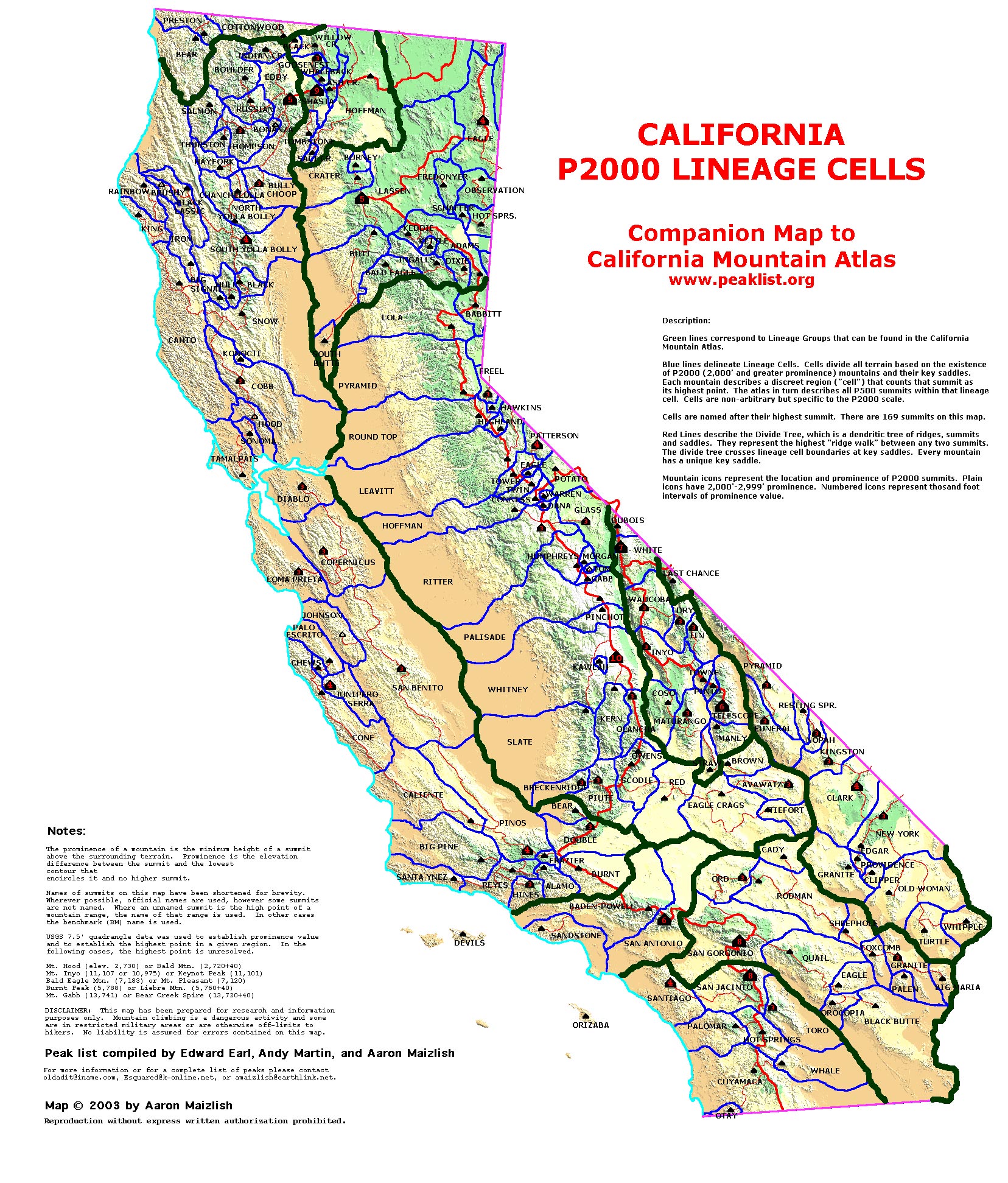
| California Cell Reference Map |
California
Mountain
Atlas Home Page |
Peaklist Home Page |
Notes
and Key to California Mountain Atlas |
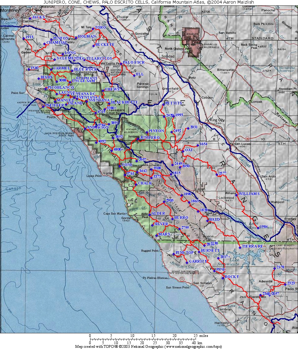
| Rank | Summit | Elevation | E(e) | Prominence | Saddle | S(e) | Lat. | Lon |
| 1 | Chews Ridge | 5045 | 35 | 2085 | 2960 | 40 | 36º18'43"N | 121º34'05"W |
| 2 | Pico Blanco | 3709 | 1629 | 2080 | 40 | 36º19'07"N | 121º48'42"W | |
| 3 | South Ventana Cone | 4965 | 1314 | 3651 | 36º16'29"N | 121º38'13"W | ||
| 4 | Uncle Sam Mtn. | 4766 | 1206 | 3560 | 40 | 36º20'28"N | 121º42'26"W | |
| 5 | Pt. 3891 | 3891 | 1091 | 2800 | 40 | 36º11'48"N | 121º32'32"W | |
| 6 | Manuel Peak | 3520 | 40 | 1080 | 2440 | 40 | 36º16'28"N | 121º46'16"W |
| 7 | Ventana Double Cone | 4853 | 973 | 3880 | 40 | 36º17'49"N | 121º42'54"W | |
| 8 | Mt. Carmel | 4417 | 897 | 3520 | 40 | 36º23'09"N | 121º47'17"W | |
| 9 | Bixby Mtn. | 2920 | 840 | 2080 | 40 | 36º21'15"N | 121º50'27"W | |
| 10 | Long Ridge | 2367 | 807 | 1560 | 40 | 36º26'19"N | 121º44'17"W | |
| 11 | Pinyon Peak | 2249 | 769 | 1480 | 40 | 36º29'20"N | 121º47'13"W | |
| 12 | Pt. 4719 | 4719 | 759 | 3960 | 40 | 36º14'09"N | 121º35'55"W | |
| 13 | San Clemente Ridge | 2706 | 586 | 2120 | 40 | 36º25'10"N | 121º46'24"W | |
| 14 | Chamisal Ridge | 2144 | 584 | 1560 | 40 | 36º28'26"N | 121º48'59"W | |
| 15 | Black Butte | 4941 | 581 | 4360 | 40 | 36º16'02"N | 121º32'28"W | |
| 16 | Launtz Ridge | 3657 | 577 | 3080 | 40 | 36º18'02"N | 121º45'52"W | |
| 17 | Pt. 1913 | 1913 | 564 | 1349 | 36º29'32"N | 121º54'14"W | ||
| 18 | Pt. 3088 | 3088 | 528 | 2560 | 40 | 36º20'38"N | 121º45'50"W | |
| 19 | Pt. 1540 | 1540 | 516 | 1024 | 36º23'11"N | 121º52'59"W | ||
| 20 | Pt. 4387 | 4387 | 507 | 3880 | 40 | 36º17'17"N | 121º41'23"W | |
| 21 | Blue Rock Ridge | 2778 | 498 | 2280 | 40 | 36º22'53"N | 121º41'55"W | |
| 22 | Ventana Cone | 4727 | 487 | 4240 | 40 | 36º17'03"N | 121º40'42"W | |
| 23 | Elephant Mtn. | 4040 | 40 | 480 | 3560 | 40 | 36º20'58"N | 121º41'23"W |
| 24 | Pt. 3280+ | 3280 | 40 | 480 | 2800 | 40 | 36º14'54"N | 121º33'40"W |