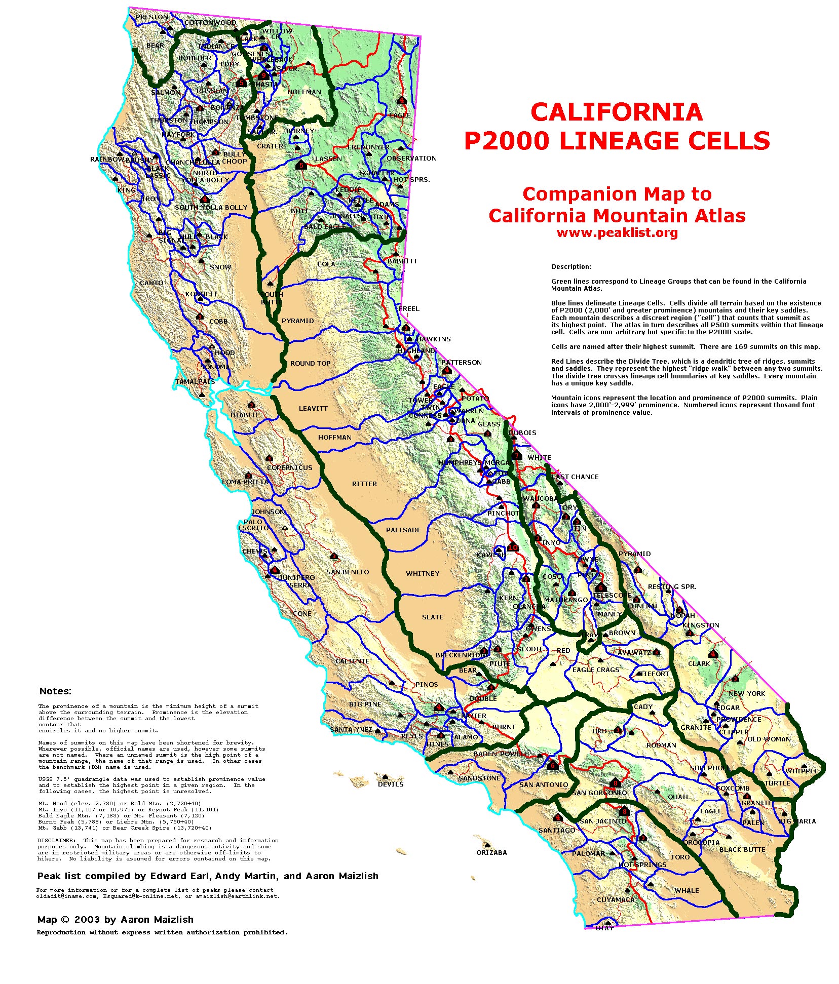
| California Cell Reference Map |
California
Mountain
Atlas Home Page |
Peaklist Home Page |
Notes
and Key to California Mountain Atlas |
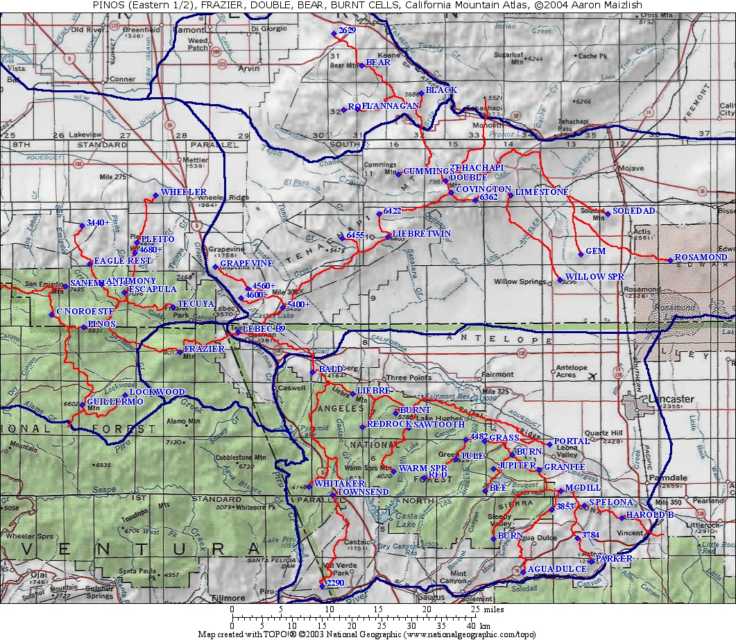
| Rank | Summit | Elevation | E(e) | Prominence | Saddle | S(e) | Latitude | Longitude |
| 1 | Burnt Peak |
5793 | 2453 | 3340 | 20 | 34º40'58"N | 118º34'35"W | |
| 2 | HP Sierra Pelona | 5217 | 23 | 1817 | 3400 | 40 | 34º32'39"N | 118º13'55"W |
| 3 | Whitaker Peak | 4148 | 1108 | 3040 | 40 | 34º34'20"N | 118º44'04"W | |
| 4 | Warm Springs Mtn. | 4020 | 1100 | 2920 | 40 | 34º35'44"N | 118º34'47"W | |
| 5 | Jupiter Mtn. | 4498 | 1077 | 3421 | 34º35'59"N | 118º23'53"W | ||
| 6 | Liebre Mtn. | 5783 | 1063 | 4720 | 40 | 34º42'46"N | 118º39'14"W | |
| 7 | Grass Mtn. | 4605 | 986 | 3619 | 34º38'28"N | 118º24'49"W | ||
| 8 | Red Mtn. | 3996 | 916 | 3080 | 40 | 34º35'12"N | 118º31'26"W | |
| 9 | Parker Mtn. | 4131 | 851 | 3280 | 40 | 34º27'35"N | 118º13'07"W | |
| 10 | BM Burn | 4541 | 821 | 3720 | 40 | 34º37'15"N | 118º21'50"W | |
| 11 | Mt. McDill | 5187 | 747 | 4440 | 40 | 34º33'58"N | 118º16'31"W | |
| 12 | BM Bee | 3717 | 677 | 3040 | 29 | 34º34'01"N | 118º24'46"W | |
| 13 | Redrock Mtn. | 4480 | 40 | 640 | 3840 | 40 | 34º39'45"N | 118º38'14"W |
| 14 | Tule Ridge | 4416 | 616 | 3800 | 40 | 34º36'53"N | 118º27'57"W | |
| 15 | Townsend Peak | 3184 | 584 | 2600 | 40 | 34º33'38"N | 118º41'29"W | |
| 16 | Pt. 4482 | 4482 | 562 | 3920 | 40 | 34º38'38"N | 118º26'53"W | |
| 17 | BM Granite | 4593 | 553 | 4040 | 40 | 34º35'51"N | 118º18'51"W | |
| 18 | Pt. 2290 | 2290 | 550 | 1740 | 20 | 34º25'26"N | 118º42'36"W | |
| 19 | HP Portal Ridge | 4007 | 545 | 3462 | 34º38'11"N | 118º17'43"W | ||
| 20 | Pt. 3853 | 3853 | 533 | 3320 | 40 | 34º32'19"N | 118º17'28"W | |
| 21 | BM Harold Beacon | 4725 | 525 | 4200 | 40 | 34º31'33"N | 118º09'50"W | |
| 22 | BM Limestone | 5362 | 522 | 4840 | 40 | 35º00'38"N | 118º21'59"W | |
| 23 | Sawtooth Mtn. | 5200 | 40 | 520 | 4680 | 40 | 34º39'39"N | 118º33'09"W |
| 24 | BM Burn | 3034 | 514 | 2520 | 40 | 34º29'41"N | 118º23'52"W | |
| 25 | Pt. 3784 | 3784 | 504 | 3280 | 40 | 34º29'45"N | 118º14'39"W | |
| 26 | BM Agua Dulce | 2843 | 483 | 2360 | 40 | 34º26'41"N | 118º20'33"W | |
| 27 | Bald Mtn. | 4520 | 40 | 480 | 4040 | 40 | 34º44'41"N | 118º43'40"W |