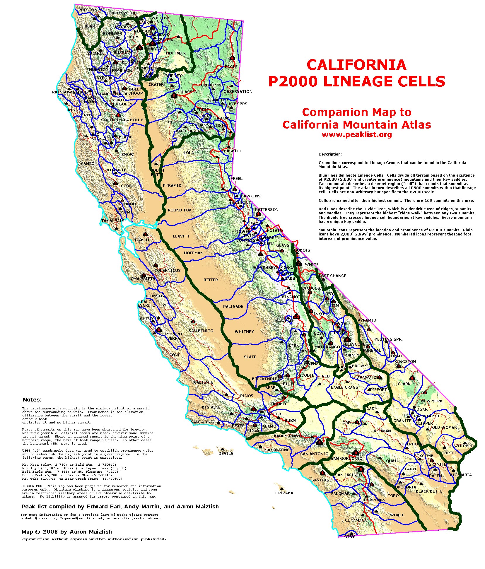
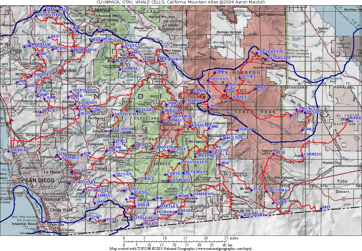
| California Cell Reference Map |
California
Mountain
Atlas Home Page |
Peaklist Home Page |
Notes
and Key to California Mountain Atlas |
| RANK | SUMMIT NAME | ELEV. | E(e) | PROM. | SADDLE | S(e) | Lat. | Long. |
| 1 | Toro Peak | 8716 | 3996 | 4720 | 40 | 33º31'25"N | 116º25'33"W | |
| 2 | Martinez Mtn. | 6562 | 38 | 1682 | 4880 | 40 | 33º33'15"N | 116º20'43"W |
| 3 | Coyote Mtn. | 3192 | 1592 | 1600 | 40 | 33º20'36"N | 116º19'43"W | |
| 4 | Asbestos Mtn. | 5265 | 1225 | 4040 | 40 | 33º37'39"N | 116º27'33"W | |
| 5 | Rabbit Peak | 6640 | 40 | 1200 | 5440 | 40 | 33º26'00"N | 116º14'22"W |
| 6 | BM Coyote | 2613 | 1133 | 1480 | 40 | 33º39'01"N | 116º20'51"W | |
| 7 | Pt. 5320+ | 5320 | 40 | 1090 | 4230 | 33º22'31"N | 116º11'29"W | |
| 8 | Pt. 6582 | 6582 | 1062 | 5520 | 40 | 33º27'34"N | 116º18'45"W | |
| 9 | BM Coolidge | 2242 | 1042 | 1200 | 20 | 33º22'56"N | 116º04'38"W | |
| 10 | Pt. 1601 | 1601 | 1041 | 560 | 40 | 33º38'47"N | 116º17'45"W | |
| 11 | Pt. 2516 | 2516 | 836 | 1680 | 40 | 33º32'40"N | 116º13'36"W | |
| 12 | Pt. 4458+ | 4458 | 22 | 738 | 3720 | 40 | 33º26'36"N | 116º22'41"W |
| 13 | Indio Mtn. | 2226 | 706 | 1520 | 40 | 33º40'16"N | 116º20'34"W | |
| 14 | Pt. 2697 | 2697 | 657 | 2040 | 40 | 33º18'28"N | 116º07'34"W | |
| 15 | Pt. 3160+ | 3160 | 40 | 600 | 2560 | 40 | 33º29'43"N | 116º14'36"W |
| 16 | Pt. 2449 | 2449 | 589 | 1860 | 20 | 33º33'05"N | 116º14'59"W | |
| 17 | Murray Hill | 2200 | 20 | 580 | 1620 | 20 | 33º45'54"N | 116º29'59"W |
| 18 | Villager Peak | 5756 | 556 | 5200 | 40 | 33º23'18"N | 116º13'08"W | |
| 19 | Pt. 1880+ | 1880 | 20 | 540 | 1340 | 20 | 33º30'23"N | 116º12'38"W |
| 20 | Pt. 4440+ | 4440 | 40 | 520 | 3920 | 40 | 33º27'52"N | 116º14'45"W |
| 21 | Pt. 4673 | 4673 | 513 | 4160 | 40 | 33º27'11"N | 116º28'37"W | |
| 22 | Pt. 4345 | 4345 | 505 | 3840 | 40 | 33º31'00"N | 116º18'52"W | |
| 23 | Sugarloaf Mtn. | 4775 | 495 | 4280 | 40 | 33º35'18"N | 116º26'05"W | |
| 24 | Black Hill | 3689 | 489 | 3200 | 40 | 33º37'38"N | 116º24'43"W |